
Placencia Map
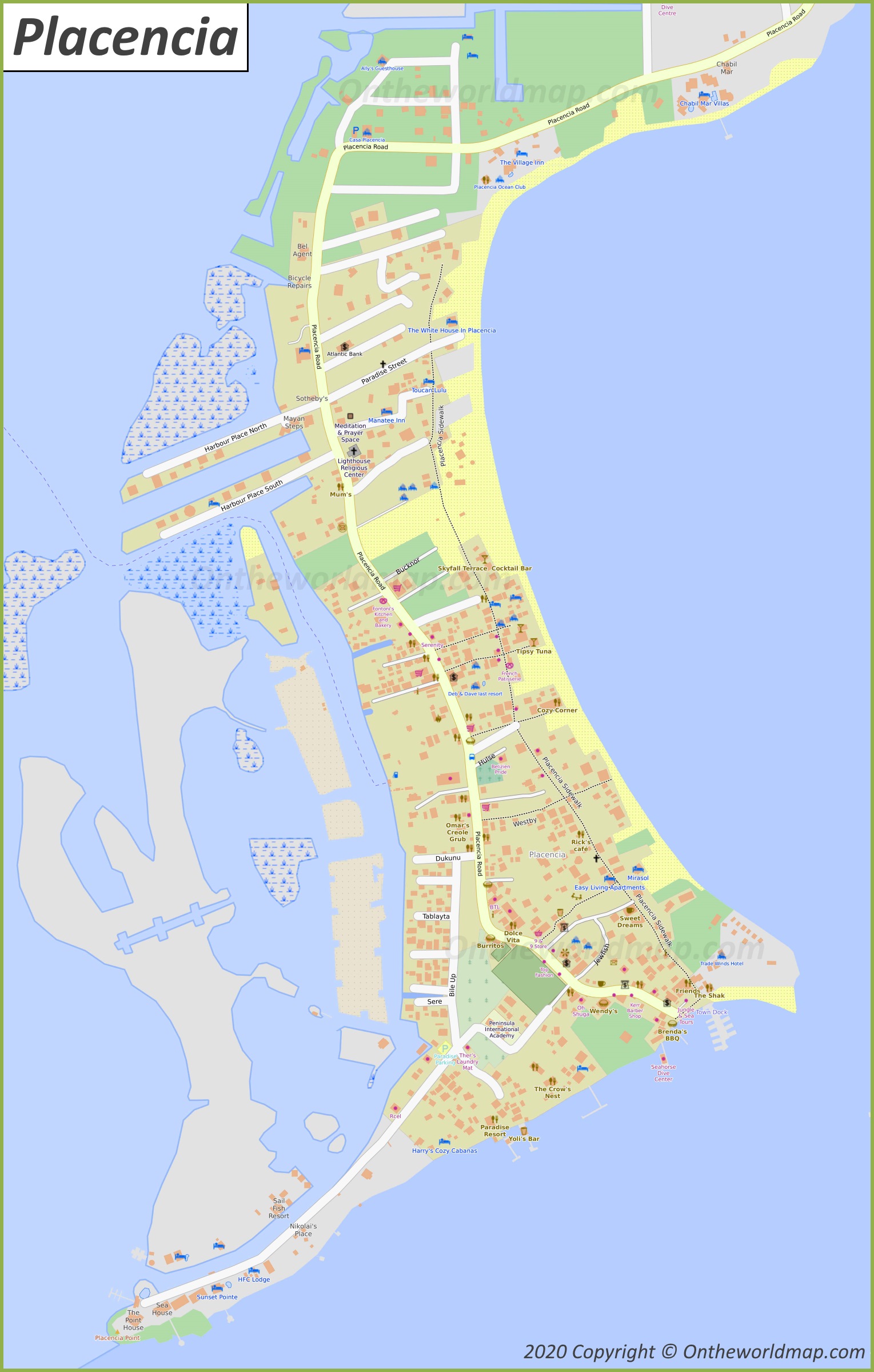
Description:
This map shows streets, trails, beaches, houses, piers, buildings, cafes, bars, restaurants, hotels, monuments, parking lots, shops, churches, points of interest, and parks in Placencia.
Size: 1529x2399px / 537 Kb
Author: Ontheworldmap.com
Map based on the free editable OSM map openstreetmap.org.
You may download, print or use the above map for educational, personal and non-commercial purposes. Attribution is required. For any website, blog, scientific research or e-book, you must place a hyperlink (to this page) with an attribution next to the image used.

Online Map of Placencia
About Placencia
Placencia is a village in the Stann Creek District of Belize. It sits at the southern tip of the Placencia Peninsula, a narrow strip of land on the Caribbean coast. The Placencia Lagoon separates the peninsula from the mainland.
The Facts:| District: | Stann Creek |
| Population (2026): | ~ 2,000 |
| Coordinates: | 16°30′50″N 88°22′0″W |
| Racial/ethnic groups: |
|
The peninsula is about 16 miles (26 km) long. Placencia is the southernmost of its settlements. The Garifuna village of Seine Bight and the community of Maya Beach lie to the north. A paved road runs along the peninsula and links it to the Southern Highway. Placencia Airport has scheduled domestic flights, and a water taxi crosses the lagoon to the town of Independence and Mango Creek.
For a long time, the local economy relied on fishing, mainly for lobster and conch. Today, tourism is the main source of income. Visitors come for the beaches and for diving and snorkelling on the nearby Belize Barrier Reef. Popular destinations close to the village include Laughing Bird Caye National Park and the Gladden Spit and Silk Cayes Marine Reserve. Whale sharks gather seasonally at Gladden Spit. Inland, the Cockscomb Basin Wildlife Sanctuary is within reach of the peninsula.
In October 2001, Hurricane Iris caused severe damage to Placencia.
The village is known for its long, narrow concrete pedestrian walkway, called "the Sidewalk," which runs through the village. Every year, Placencia holds a Lobsterfest to mark the opening of the lobster fishing season.
Maps of Belize
Cities of Belize