
Belize City Map
Description:
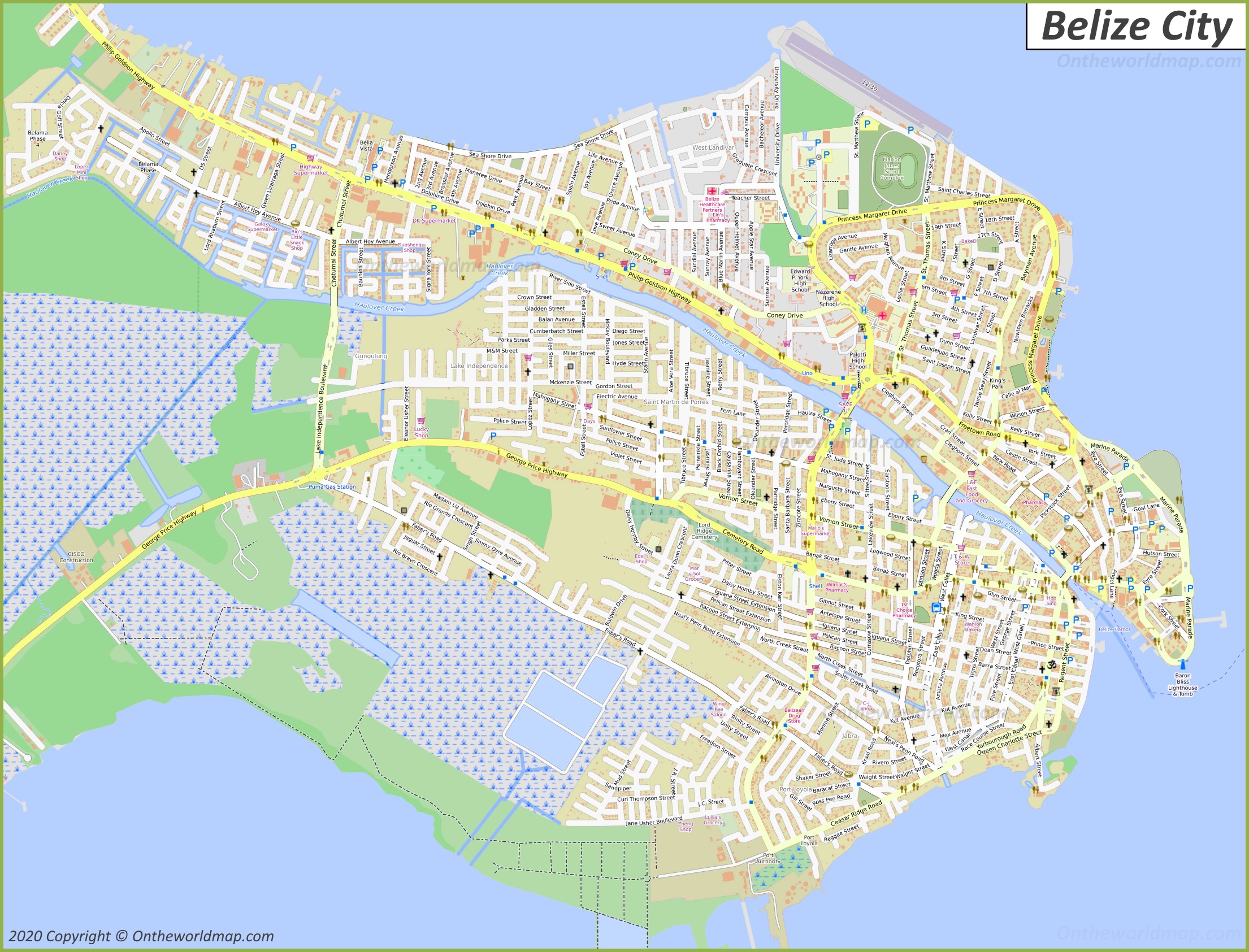
This map shows neighborhoods, streets, roads, piers, lighthouses, shops, parking lots, rivers, buildings, airport, and parks in Belize City.
Size: 2210x1685px / 1.12 Mb
Author: Ontheworldmap.com
Map based on the free editable OSM map openstreetmap.org.
You may download, print or use the above map for educational, personal and non-commercial purposes. Attribution is required. For any website, blog, scientific research or e-book, you must place a hyperlink (to this page) with an attribution next to the image used.

Description:
This map shows streets, trails, houses, piers, buildings, cafes, bars, restaurants, hotels, museums, parking lots, shops, churches, points of interest, playgrounds, and parks in Downtown Belize City.
Size: 2484x3109px / 1.68 Mb
Author: Ontheworldmap.com
Map based on the free editable OSM map openstreetmap.org.
You may download, print or use the above map for educational, personal and non-commercial purposes. Attribution is required. For any website, blog, scientific research or e-book, you must place a hyperlink (to this page) with an attribution next to the image used.

Online Map of Belize City
About Belize City
Belize City is the largest city in Belize and the country's main port and commercial centre. It lies on the Caribbean coast in the Belize District, at the mouth of Haulover Creek, a branch of the Belize River. The city was the capital of British Honduras until 1970.
The Facts:| District: | Belize |
| Population (2025 estimate): | 75,592 |
| Density: | 5,480/sq mi (2,120/sq km) |
| Area: | 13.8 sq mi (35.7 sq km) |
| Coordinates: | 17°29′55″N 88°11′19″W |
The settlement was founded in the 17th century by British loggers known as the Baymen, who cut logwood and later mahogany in the area. It became the main centre of the British colony. In 1798 the Baymen defeated a Spanish force at the Battle of St. George's Caye, near the city. Belize City was badly damaged by a hurricane in 1931. In 1961 Hurricane Hattie caused widespread destruction, and the government decided to move the capital inland. In 1970 the capital moved to Belmopan.
Haulover Creek divides the city into the Northside and the Southside. The city is built on low, swampy ground and lies only slightly above sea level.
Belize City has several historic buildings. St. John's Cathedral was built between 1812 and 1820 and is regarded as the oldest Anglican church in Central America. The Belize Swing Bridge opened in 1923. It crosses Haulover Creek and is one of the few manually operated swing bridges still in use. The Museum of Belize is housed in a former colonial prison built in 1857. The former Government House now operates as the House of Culture.
The city is served by Philip S. W. Goldson International Airport in nearby Ladyville, the country's main international airport. Cruise ship tourism is an important part of the local economy.
Main sights in Belize City
- Swing Bridge
- St. John's Cathedral
- Museum of Belize
- Government House (House of Culture)
- Fort George Lighthouse and Baron Bliss Tomb
- Belize Supreme Court Building
- Battlefield Park
- Image Factory Art Foundation
- Bliss Center for the Performing Arts
- Memorial Park
Maps of Belize
Cities of Belize