
Ronald Reagan Washington National Airport Map
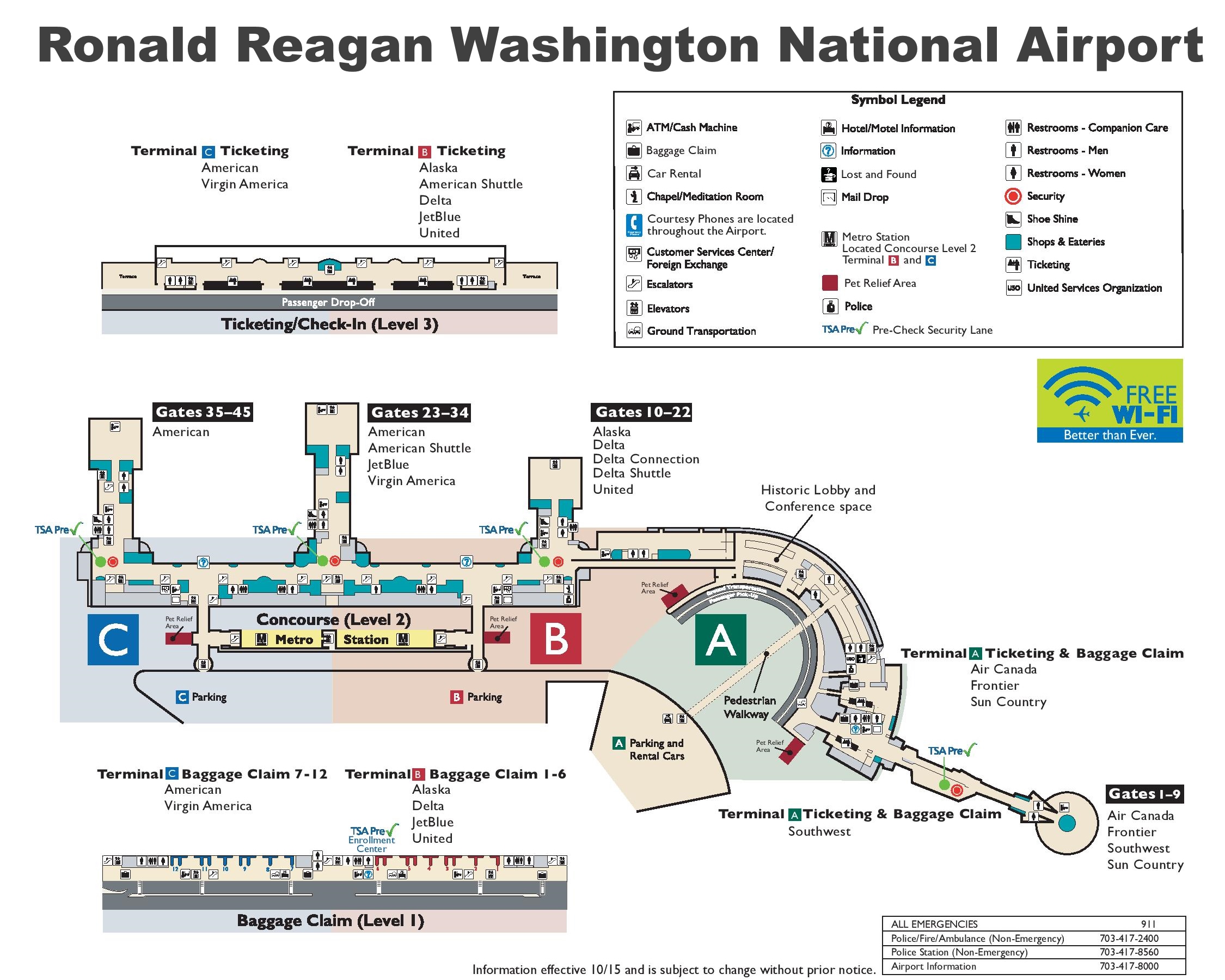
Description:
This map shows terminals, gates, baggage claim, car rental, chapel, hotel information, information centers, lost and found, metro stations, restrooms, and ticketing in Ronald Reagan Washington National Airport.
About Ronald Reagan Washington National Airport
Ronald Reagan Washington National Airport (IATA: DCA, ICAO: KDCA) is a public airport in Arlington County, Virginia, about 3 miles (5 km) south of downtown Washington, D.C. It is the closest commercial airport to the U.S. capital and handles mostly domestic flights. The airport sits on the western bank of the Potomac River. Since 1987 it has been operated by the Metropolitan Washington Airports Authority, which also runs Washington Dulles International Airport.
The airport opened on June 16, 1941, as Washington National Airport. It replaced the earlier Washington-Hoover Airport, and President Franklin D. Roosevelt laid its cornerstone in 1940. It was built at Gravelly Point, partly on land reclaimed from the Potomac River. The remains of the colonial-era Abingdon plantation lie on the airport grounds. In 1998, President Bill Clinton signed legislation renaming the airport after former President Ronald Reagan.
Flights at the airport are limited by a "perimeter rule." Under this rule, nonstop flights are generally restricted to destinations within 1,250 miles (2,010 km). Congress has granted a limited number of exemptions for longer routes. The airport is also slot-controlled.
The airport has three runways. The longest, Runway 1/19, is 7,169 feet (2,185 m) long. Because the airport is close to restricted airspace over central Washington, aircraft must follow special noise-abatement and security procedures. Many arrivals and departures fly along the Potomac River. After the September 11 attacks in 2001, the airport closed for several weeks and reopened with stricter security measures.
The main terminal complex opened in 1997 and was designed by architect César Pelli. The original 1941 terminal building is still in use. In 2021, a new concourse with 14 gates opened as part of a modernization program known as Project Journey. American Airlines is the largest carrier at the airport. The airport is served by its own station on the Blue and Yellow Lines of the Washington Metro.
Two major accidents have happened near the airport. On January 13, 1982, Air Florida Flight 90 crashed into the 14th Street Bridge shortly after taking off from National, killing 78 people. On January 29, 2025, American Eagle Flight 5342 collided with a U.S. Army Black Hawk helicopter over the Potomac River while approaching the airport. All 67 people aboard both aircraft were killed.
You may download, print or use the above map for educational, personal and non-commercial purposes. Attribution is required. For any website, blog, scientific research or e-book, you must place a hyperlink (to this page) with an attribution next to the image used.
U.S. Maps
Cities of USA
States of USA
States of USA